

While traveling is off the cards, with the fast clearing trails, there is no better time than now, to explore local.
Part One was all about Going Virtual. An opportunity to take advantage of one of the many varied, fun, challenging, introductory, virtual races that are currently on offer across the globe. Maybe you jumped on the virtual train, maybe that wasn’t for you – in which case, below are a couple amazing tools to help you Explore Local.
If you missed Part One, check it out HERE, then have a read of Part Two below. Then be sure to reach out if you need a little nudge, advise or route ideas.
PART TWO: EXPLORE LOCAL.
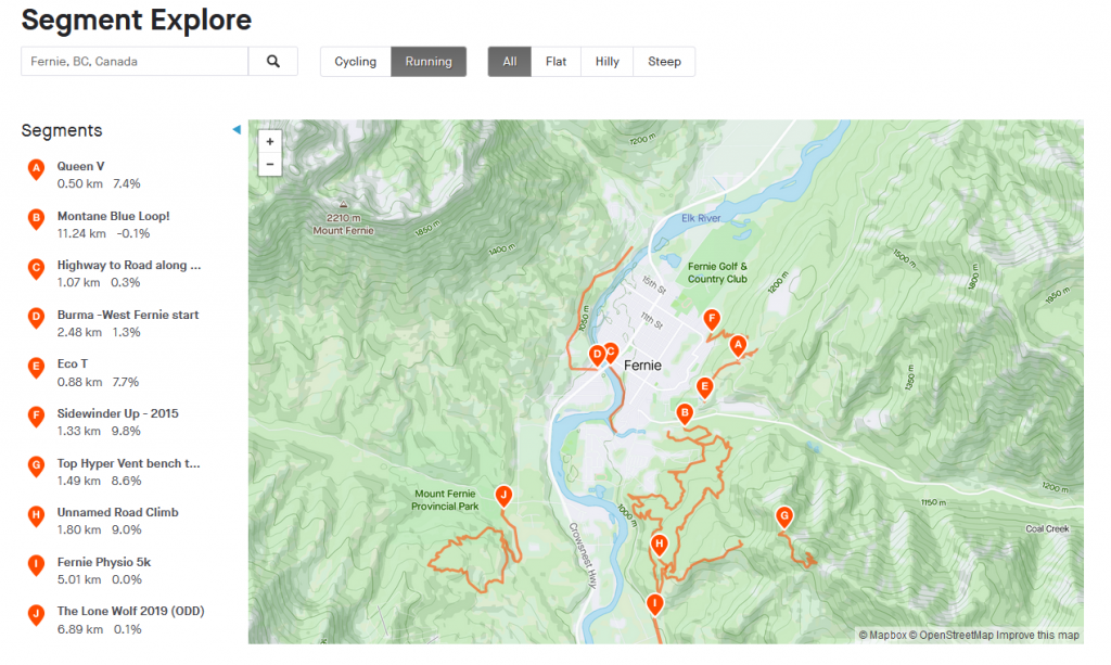
First up, Strava. A valuable and increasingly popular tool. If you’re yet to try it, due to rumours of its competitive nature, there is nothing to be afraid of. Catering to the novice and the expert and everyone in between, Strava is a great, sociable (or not), way to help you stay accountable and if you’re that way inclined, challenge yourself (a little or a lot).
It is also free, very user-friendly, and increasingly used for a variety of local challenges – such as Fernie Alpine Resort’s Silk Trail Sprints, or our virtual Lone Wolf, last summer.
Plus, if you’re not into purchasing a GPS watch, you can simply take your phone with you, to track your mileage. No further gear required. Except bear spray.
You can get as involved as much as you like, by following friends, fellow athletes, your idols; joining Strava Clubs (think facebook); tackling a segment or creating your own; or taking on a weekly or monthly Strava Challenge (like a free Virtual Race, but with zero competition, frills or cost, just personal achievement).
Or, you can be in 100% stealth mode, and not share a step with anyone. Just your own little personal trainer, guide, support system and timing system, all rolled into one.
Still confused? Luckily, Runner’s World has a great how-to guide, detailing all the ins and outs of this great free tool. Read all about it, below, then get yourself a free account and see what’s in it for you.
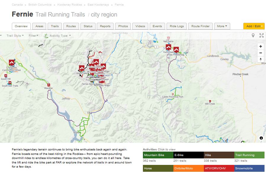
Secondly, Trailforks. An increasingly popular tool, to help you stay on course when you’re out on the trails.
Trailforks is a trail database with hundreds of thousands of trails. Users can contribute data and then local trail associations, (such as the Fernie Trails Alliance, here in Fernie), have the control to approve and curate the data – ensuring an up-to-date trail guide awaits you. From new trails, to closed to trails; blues to blacks; nordic to multi-use; Trailforks details out all the specifics you need to both pre-plan your run, and check in while on the trails, to ensure you’re heading in the right direction.
We’re really lucky here in Fernie that our local area is kept so up-to-date, ensuring that you have a fantastic map to utilize from home, and while on the trails. You too can also get in on the action. Maybe you ran a trail, with a huge tree down or a massive mud hole? Once home (or via the mobile version on-trail), you can submit a “trail report” – so that other users can see first hand, the current status. And of course, this assist the FTA’s amazing trail crew, in getting out there to clear any hazardous debris.
While the desktop version is great for planning (or exploring from your couch), the Trailforks app is your mobile companion allowing you to download offline trail maps for use on your runs, rides, hikes or Nordic Skis. Yep, it’s a year-round must.
Trailforks is free. However, if you want to be able to access it in multiple locations (outwith Fernie), you’ll need to upgrade, but it’s not expensive and well worth it.
Lastly, Trailforks is a must, when it comes to Search + Rescue, as it allows you to easily share your location direct with Fernie Search + Rescue (FSAR) via the emergency button, to greatly assist in getting you quickly to safety. Read more about FSAR’s tips to safety, HERE.
Then check out Trailforks via the link below, and download the app, now!
Thirdly, time for a little trail maintenance. This is the time of year where blow down is ripe, with a number of hazards littering the trails. Again, here in Fernie we are so lucky at the number of keen, willing and hardworking volunteers who assist in clearing trails year-round. However, us runners can help! From simply picking up rogue pieces of tree; to carrying a small saw in your pack; to reporting larger hazards on trailforks – every little helps in fast clearing the trails. And rumour has it, it results in excellent trail karma.
Lastly, get your Fernie Trails Pass! Whether a runner, hiker or biker, the only way to directly support the Fernie Trail Network, is buy purchasing an annual (or day, or weekend), Trails Pass via the Fernie Trails Alliance. All funds from these sales go directly into maintenance of the trail network, plus, it ensures (through the signing of your digital waiver), the security of the FTA and the many generous Private landowners. Win, win, win.
That’s it, folks! We hope this helps you have a fun summer of exploring local. Guaranteed, you will find a new route, trail or favourite loop, that you didn’t know of.
#StaySmart #StaySafe and #StopTheSpread


Leave a Reply
Your email is safe with us.